

Knowing the phenomenon
The climate is changing, with more frequent heat waves over the past 30 years. These are set to multiply and greatly increase by 2100.
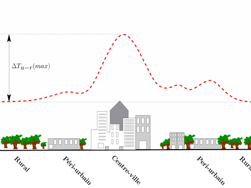
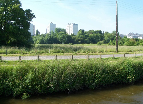
Combined with the increase in population and urban densification, climate change will make the phenomenon of urban heat islands (UHIs) more significant, i.e. an increase in air and surface temperatures in city centres versus outskirts, particularly at night.
This phenomenon has diverse impacts: consequences on health, on the well-being of residents, on the "practicability" of public spaces and therefore on the attractiveness of town centres, on energy consumption (air conditioning), on the resilience of infrastructures and urban networks and the maintenance of animal and plant biodiversity.
The UHI phenomenon is linked to several factors:
-
The thermophysical properties of the materials used for the construction of buildings, roads and other infrastructures,
-
Land use (mineralised soils, absence of vegetation)
-
Urban morphology (major traffic lanes, urban «roughness» reducing convection…)
-
Heat release from human activities (engines, heating and air conditioning systems…)
Urban materials store heat (15 to 30% more than less dense areas) during the day which is released at night. It is for this reason that the UHI phenomenon is more pronounced at night, preventing temperatures from falling again.
Tools for local authorities
Cerema conducts innovation and expert assessment work on the subject, with micro-meteorological measurement methods carried out using either an instrumented vehicle or via networks of fixed sensors.
Satellite imagery and the use of geomatics also serve to produce multi-criteria urban indicators and to zone the various spaces according to their climatic conditions using a simplified statistical approach.
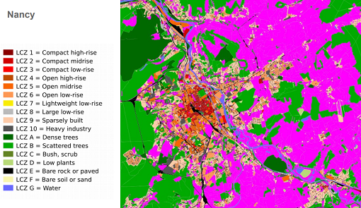
This approach was developed in the DIACLIMAP project, subsidised by Ademe (2015-2017), whose objective was to allow the problem of UHIs to be integrated into urban development planning, taking into account the parameters of urban morphology and land use. The methods developed are used to map the city according to local climate zones (LCZ) from various geographic databases and PLEIADES satellite images. At the output, localised UHI potential indicators can serve as inputs for an expert diagnosis.
In 2018, Ademe called on Cerema and a design office to establish a broader collection of urban overheating diagnostic methods, used to determine the importance of the phenomenon on a fine scale.
This inventory was drawn up on the basis of experience feedback from five cities having carried out such a diagnosis (Bordeaux, Nancy, Nice, Lille and Mantes-la-Jolie).
Acting against heat islands
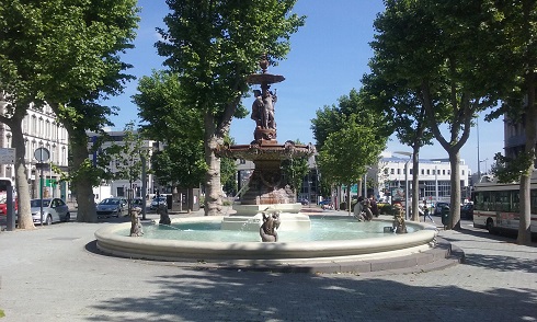
The City of Clermont-Ferrand is also experiencing a problem of urban overheating and is deploying a strategy to adapt to climate change.
As part of the redevelopment of a central square in the city, Place Delille, the City wanted to act on the UHI phenomenon and summer comfort within the public space.
With the Cerema and the local town planning agency, the City has undertaken to characterise the phenomenon by means of fixed and mobile instrumentation on the square and its surroundings, to record the temperatures and hygrometry (humidity) both during the day and at night, in summer and in winter. The project combines measures with the feelings of the inhabitants in order to objectify the UHI phenomenon.
It appeared that Place Delille is hotter at night, from 2 to 3 °C, than the outskirts, because the heat accumulated during the day is restored at night. The causes of this UHI phenomenon are then analysed, to establish a benchmark that will serve as a basis for the implementation of the future strategy.
After having objectivised the UHI phenomenon, a decision support tool will be developed to guide communities in the choice of actions to be implemented against the UHI phenomenon. The experiment carried out at Place Delille will then be extended to other municipalities. The study has just started, and will end by 2021-2022.
With the City of Greater Nancy, where the Diaclimap project was carried out, Cerema is carrying out until 2021 a study of the vulnerability of neighbourhoods to urban heat islands, by cross-referencing socio-demographic, construction and energy quality indicators of buildings, with a view to identifying areas at stake and allowing the implementation of adaptation actions via town planning documents.
Over time, many cities have become aware of the problem of urban overheating and its challenges, and are wondering about the strategy and actions to be implemented to mitigate this phenomenon.
The solutions to be developed to deal with urban heat islands must be adapted to the local context and climate. In this domain, Cerema can bring its expertise and study capabilities to urban agglomerations of all sizes, from large cities to medium-sized urban agglomerations.
Main guidelines for the fight against urban heat islands:
-
Strengthen the presence of nature and water within development projects;
-
Promote favourable environments in a context of increasing heat waves;
-
Optimise spatial organisation
-
Promote an appropriate technical design
-
Promote a design that integrates management needs, uses and practices.
3 examples of developments that promote freshness in the city
In order to improve urban development in light of the heat island problem, local authorities have access to "green" solutions linked to nature and plants, "blue" solutions linked to the presence of water, or even so-called "grey" solutions linked to urban materials.
Examples of developments that address the UHI phenomenon
-
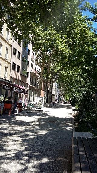
Rue Garibaldi in Lyon, an urban boulevard nearly 5 km long, completely redeveloped in 3 phases: wider pedestrian paths, installation of benches, creation of cycle paths, a bus lane in addition to traffic lanes, establishment of 'trees, light-coloured coverings which absorb more heat, ditch to collect run-off water. The site is fitted with temperature sensors to assess fresh air input, as well as to detect any thermal stress of the trees and a need for watering, by means of the water stored in an underground basin.
-
The Clichy Batignolles EcoQuartier: located on 54 hectares of former SNCF wasteland, the EcoQuartier, which will eventually be able to accommodate 3,400 housing units and 12,000 jobs in the north-east of inner Paris, was designed to take into account the UHI phenomenon. Urban spaces meet the objective of refreshing users: 10 ha wooded park in addition to natural spaces, light-coloured alleys, presence of water (fountains, water jets), alternative rainwater management (recovery, storage and distribution in a biotope basin), buildings designed for significant summer comfort. The site, which should allow a drop of 2°C during a heat wave, will also be a biodiversity reserve.
-
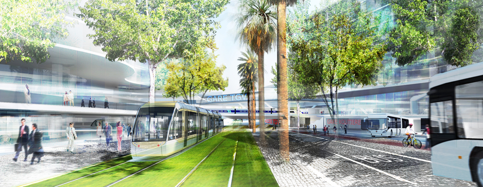
The Saint-Augustin multimodal hub, near Nice airport and a business district, was designed using the EnviMet tool, used to simulate climatic conditions at the building or neighbourhood scale. The project has been improved, particularly in terms of:
-
densification of plant masses, in order to reduce the phenomenon of wind acceleration, and to create shade;
-
modification of the master plan by moving a building project,
-
implementation of innovative solutions around air and soil humidification: watering the roadway, via a spray nozzle integrated into a sidewalk and installation of water-retaining paving stones.
-
Agir contre les îlots de chaleur
La Métropole de Clermont-Ferrand connaît elle aussi un problème de surchauffe urbaine et déploie une stratégie d’adaptation au changement climatique.
Dans le cadre du réaménagement d’une place centrale de la ville, la place Delille, la Métropole a voulu agir sur le phénomène d’ICU et le confort d’été au sein de l’espace public.
Avec le Cerema et l’agence d’urbanisme locale, la Métropole a entrepris de caractériser le phénomène par une instrumentation fixe et mobile sur la place et ses abords, pour relever les températures et l’hygrométrie (l’humidité) de jour comme de nuit, aussi bien en été qu’en hiver. Le projet combine des mesures avec le ressenti des habitants afin d’objectiver le phénomène d’ICU.
Il est apparu que la place Delille est plus chaude la nuit, de 2 à 3°C, que la périphérie, car la chaleur accumulée durant la journée est restituée la nuit. Les causes de ce phénomène d’ICU sont ensuite analysées, pour établir un référentiel qui servira de base à la mise en œuvre de la stratégie future.
Après avoir objectivé le phénomène d’ICU, un outil d’aide à la décision sera élaboré pour guider les collectivités dans le choix des actions à mettre en œuvre contre le phénomène d’ICU. L’expérimentation menée à la place Delille sera ensuite étendue à d’autres communes. L’étude vient de démarrer, et prendra fin à l’horizon 2021-2022.
Avec la métropole du Grand Nancy, où a été mené le projet Diaclimap, le Cerema réalise jusqu’en 2021 une étude de la vulnérabilité des quartiers aux îlots de chaleur urbains, en croisant des indicateurs socio-démographiques, de,qualité constructives et énergétique du bâti, de manière à identifier des zones à enjeu et permettre la mise en œuvre d’actions d’adaptation via les documents d’urbanisme.